Race proposal
Vorkloster Run 2026
Competitors can look forward to three exciting stages, which can be completed solo or as a relay in pairs. Each stage has its own unique character. Saturday will begin with a shorter, flat, fast stage on high-quality asphalt, followed in the afternoon by a longer, hilly off-road stage with breathtaking views of the countryside. Sunday’s program will then culminate with an exciting final stage starting with the Gundersen method, which will bring the weekend’s experiences and emotions to a thrilling climax.
About the race
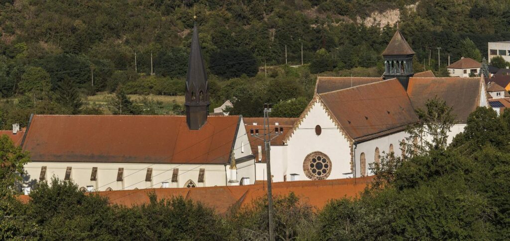
The entire race takes place in the beautiful surroundings of the Bohemian-Moravian Highlands and the unique atmosphere of the medieval Porta Coeli monastery, which was founded in the 13th century by Constance, wife of Czech King Přemysl Otakar I. The event is organized by the experienced DálRunDál team in cooperation with the Porta Coeli Monastery Brewery. This brewery, which focuses on bottom-fermented beers and specials produced according to original recipes under the VORKLOSTER brand, contributes to an authentic experience.
STAGE 1
5 km, start 10:00 a.m., Saturday, September 5
START
The bike path behind the bridge over Loučka. The start is approximately 650 meters from the registration point.
ROUTE LENGTH
5 km (no elevation gain)
ROUTE SURFACE
Asphalt approx. 3.5 km, paved gravel roads approx. 1.5 km
TEAM HANDOVER
STAGE 2
11.4 km, start at 2:00 p.m., Saturday, September 5
CELEBRATORY START
Náměstí Předklášteří
OFFICIAL START
Approximately 800 meters away. The transfer is joint, at a leisurely pace, approximately 6.00 min/km
ROUTE LENGTH
11.4 km (elevation gain 343 meters)
GPS ROUTE
ROUTE SURFACE
Forest and paved gravel roads approx. 11.0 km, asphalt approx. 0.4 km
REFRESHMENTS
At 5 km at the crossroads before the village of Úsuší as part of the team handover
TEAM HANDOVER
At 5 km at the crossroads before the village of Úsuší
STAGE 3
14.7 km, start 10:15 a.m., Sunday, September 6
START
At the municipal office in Předklášteří
ROUTE LENGTH
14.7 km (elevation gain 264 meters)
ROUTE GPS
ROUTE SURFACE
Forest and paved gravel roads approx. 11.3 km, asphalt approx. 3 km
REFRESHMENTS
At 9.2 km Dolní Loučky
TEAM HANDOVER
No later than 13 km after the bridge over Loučka. The meeting point is approx. 650 meters from the complex.
STAGE 1
A fast, flat stage on high-quality asphalt, mostly on bike paths away from road traffic. The route follows the Svratka River and Besének Creek and offers beautiful views of Květnice Hill. Thanks to its flat profile and solid surface, it is ideal for running in road running shoes. The route will be clearly marked with arrows.
STAGE 2
A hilly stage with a more demanding profile, leading through easy terrain on paved forest and field paths off the asphalt. The route heads southwest from Předklášteří towards Deblín and offers panoramic views of the foothills of the Bohemian-Moravian Highlands and the monastery complex. Right after the start, there is a long and sometimes steep climb, during which you will ascend almost 150 meters in 1.7 km with an average gradient of 8.5%. Most of the route follows cycle paths and tourist trails and will be carefully marked with arrows and flags.
STAGE 3
A moderately difficult stage with one significant climb in the first half and a flat finish. The route heads west from Předklášteří towards Dolní Loučky and back, passing under two unique train viaducts from the middle of the last century. The surface is a combination of forest and field paths, ending on asphalt in Dolní Loučky and Předklášteří. The entire route will be carefully marked with arrows and flags. The start will be based on the Gundersen method with time intervals according to the results of the previous two stages.

Team race – sections and handovers
The team decides on the deployment of individual members on the sections before the stage. The second member of the team is allowed to run and support their partner on their section as well.
STAGE 1
The first stage has sections of 4.8 km and 4.5 km, with the handover taking place at the municipal office in Štěpánovice. The handover point is also located at the 6.8 km mark of the route – in exceptional cases, the race director may, upon request, allow the handover to take place here if it enables a weaker runner to continue the race (this is not a tactic to improve time).
🚍 Transportation: Shared bus transport approx. 10 minutes before the start from the parking lot at the start. Individual transport by car is permitted; please park in the designated areas.
⚠️Important: Do not start running with your start number on the bridge over the Svratka River – this is where the split time is measured. After the last relay baton is handed over, the bus returns to the parking lot.
STAGE 2
The second stage offers two transfer options:
🔹 Before the village of Deblín: 7.9 km (↑306 m ↓77 m) and 11.5 km (↑167 m ↓386 m).
🔹 Behind the village of Deblín: 10.0 km (↑344 m ↓115 m) and 9.4 km (↑129 m ↓348 m).
🚍 Transportation: Shared bus transportation immediately after the mass start. Individual transportation by car is permitted, but please park only in designated areas.
⚠️ Important: Do not run with your start number over the chip timing measurement point. After the last relay has been handed over, the bus will return to the finish line.
STAGE 3
The third stage (15 km, ↑264 m) is not divided into sections – at least one team member must complete the entire stage. The second member may join them at any time, but no later than at the 13th km (behind the bridge over Loučka), so that they can run the final 2 km together (max. distance between them is 2 seconds).
🚗 Teams are responsible for their own transportation to the meeting point. The bridge over Loučka is approximately 650 m from the start/finish line. Another option is the buffet in Dolní Loučky (9.2 km), located 400 m from the Dolní Loučky-Mezihoří bus stop, from where a regular bus service operates (10:43, IDS-JMK, not provided by the organizer).
⚠️ Important: Do not run with your start number over the chip timing measurement point.